File:Serious Gaming - exemplary study - Wascher et al. 2010 - Land Use Functions Map 1.png
From Sustainability Methods
Revision as of 08:39, 30 July 2021 by Christopher Franz (talk | contribs)

Size of this preview: 767 × 599 pixels. Other resolutions: 307 × 240 pixels | 1,007 × 787 pixels.
Original file (1,007 × 787 pixels, file size: 623 KB, MIME type: image/png)
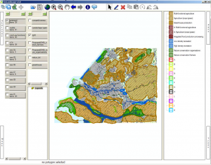
The Land Use Functions Map of the current state of the Rotterdam region. Source: Wascher et al. 2010, p.43
File history
Click on a date/time to view the file as it appeared at that time.
| Date/Time | Thumbnail | Dimensions | User | Comment | |
|---|---|---|---|---|---|
| current | 08:39, 30 July 2021 | | 1,007 × 787 (623 KB) | Christopher Franz (talk | contribs) |
- You cannot overwrite this file.
File usage
The following page uses this file: