Difference between revisions of "Walking Exercise"
| Line 14: | Line 14: | ||
[[File:Transect-walk.png|thumb|right|source: https://www.spool.ac/index.php/spool/article/view/35]] | [[File:Transect-walk.png|thumb|right|source: https://www.spool.ac/index.php/spool/article/view/35]] | ||
| − | '''Mental mapping''' stems from the field of behavioural geography and was especially coined by Kevin Lynch and his work “The Image of the City” (3). It captures how people perceive their urban environment. Practically speaking, a person’s image of a city is their mental map of it. The map usually entails the following characteristics: | + | '''[[Mental Maps | Mental mapping]]''' stems from the field of behavioural geography and was especially coined by Kevin Lynch and his work “The Image of the City” (3). It captures how people perceive their urban environment. Practically speaking, a person’s image of a city is their mental map of it. The map usually entails the following characteristics: |
* paths: routes along which people move throughout the city; | * paths: routes along which people move throughout the city; | ||
* edges: boundaries and breaks in continuity; | * edges: boundaries and breaks in continuity; | ||
| Line 22: | Line 22: | ||
'''Exploratory walking''' (or transect walking) is a method from the field of city planning often used for observation-based community improvement. Its aim is the gathering of data and experience of one’s own daily environment in a systematic way that transform one’s own perception of it, thereby gaining deeper understanding. This means walking through the environment along a defined path across an area and taking notes on what stands out. Often, it is done in small groups in order to be able to exchange with others. | '''Exploratory walking''' (or transect walking) is a method from the field of city planning often used for observation-based community improvement. Its aim is the gathering of data and experience of one’s own daily environment in a systematic way that transform one’s own perception of it, thereby gaining deeper understanding. This means walking through the environment along a defined path across an area and taking notes on what stands out. Often, it is done in small groups in order to be able to exchange with others. | ||
| − | |||
==What the method does== | ==What the method does== | ||
Latest revision as of 12:51, 5 November 2024
Quantitative - Qualitative
Deductive - Inductive
Individual - System - Global
Past - Present - Future
In short: Mental Maps are a visual representation of how people perceive their daily environment and how people orient themselves in it. The Walking Exercise makes use of this strategy to initially build sustainability competencies in higher education settings.
Contents
Background
The world and environment are in a critical state as there are certain sustainability challenges, such as biodiversity loss, global warming, limited resources, and increased inequalities. From this, the need to react to them arises, both locally and globally. Developing certain sustainability competencies (skills, abilities) can be a start to learn how to do so. Wiek et al. (1) have sketched out five competencies that should be considered for academic program development. These are as follows: systems thinking, anticipatory competence, normative competence, strategic competence, and interpersonal/collaborative competence. Based on these, Caniglia et al. (2) have worked out a method, aiming at building some of the aforementioned competencies, which is called Walking exercise. The method combines mental mapping and exploratory walking.
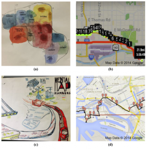
Mental mapping stems from the field of behavioural geography and was especially coined by Kevin Lynch and his work “The Image of the City” (3). It captures how people perceive their urban environment. Practically speaking, a person’s image of a city is their mental map of it. The map usually entails the following characteristics:
- paths: routes along which people move throughout the city;
- edges: boundaries and breaks in continuity;
- districts: areas characterized by common characteristics;
- nodes: strategic focus points for orientation like squares and junctions;
- landmarks: external points of orientation, usually an easily identifiable physical object in the urban landscape.
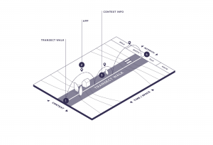
Exploratory walking (or transect walking) is a method from the field of city planning often used for observation-based community improvement. Its aim is the gathering of data and experience of one’s own daily environment in a systematic way that transform one’s own perception of it, thereby gaining deeper understanding. This means walking through the environment along a defined path across an area and taking notes on what stands out. Often, it is done in small groups in order to be able to exchange with others.
What the method does
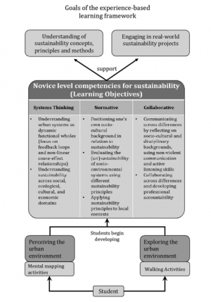
The walking exercise is a bottom-up, student-centered, and experience-based method in higher education settings to develop sustainability competencies in local contexts. It is meant for students with no or little previous knowledge in sustainability science, for example first-semester students in the environmental sciences realm and spans over one semester.
The goal is to actively engage with sustainability problems in one’s surroundings from the beginning on and thereby understand concepts, principles, methods of sustainability and think about solution options.
Essential for this is the development of sustainability competencies, especially systems thinking, normative, and collaborative competencies as named by Wiek et al. (2011).
Systems thinking means the ability to analyze complex systems and problems across different domains (society, economy, environment) and scales (local to global) in order to engage with and tackle them. Normative competencies, or “value-focused thinking”, stands for the evaluation of sustainability through different sustainability principles and the ability to discuss and apply values, habits, perceptions and experiences. It is tightly connected with ethics and touches upon reflecting on one’s own position as well. Being able to motivate people and facilitate group processes using non-violent and empathetic communications, as well as actively listening, is the essence of collaborative competencies. As it describes practices between people, it is called interpersonal competence also.
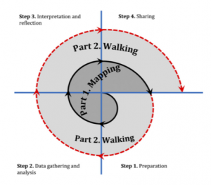
In order to foster these competencies, students shall perceive and explore their urban environment using mental mapping activities and walking activities (connecting the learning objectives directly with one’s own experience). To do so, both phases (mapping and walking) are performed after one another and share the same four sub-steps: preparation, data gathering and analysis, interpretation and reflection, and lastly, sharing.
In their learning experience, students are supported by an instructor who guides them by preparing methodological/theoretical inputs, reflection questions, and facilitates in-class discussions. However, it is by no means a frontal teaching style but rather a source of support if needed, as students should learn from their own experiences.
The table below displays an ideal-typical process of the Walking exercise.
| phase | step | description | output |
|---|---|---|---|
| mental mapping: perceiving sustainability | preparation | After the class instructor has given a short input on theoretical and methodological foundations on how to visualize and map spaces, students develop a sketch of how they perceive their urban environment and what meaning or feeling certain places hold for them. They complement their sketches with a short questionnaire. Students then compare similarities and differences between their sketches using Lynch’s elements (paths, edges, districts, nodes, landmarks) and discuss what might be the reason for this. | individual sketch of map; short questionnaire |
| data gathering and analysis | Students learn basic principles about analyzing qualitative data (here: sketches and answers to questionnaires) based on input given by the instructor. They then proceed to interview other people outside of class with their prior developed questionnaires in teams. Afterwards, they code their data on recurring places, feelings, and meanings. In a spreadsheet, students compare the collected answers with their own sketches. | spreadsheet | |
| interpretation and reflection | In an attempt to interpret their findings, students specifically look at how different places are connected to one another in people’s experience of the urban environment. They finally visualize their findings into one single image called a shared mental map. Afterwards, they learn about concepts and principles of sustainability and identify a specific local sustainability issue. They assess this selected area or community regarding (un)sustainability. Taking the personal background of their interviewees into account, students reflect on how this might have shaped the answers they received, as well as their own image of the city. Optionally, they visualize (non-)linear cause-effect structures and feedback loops in a causal systems diagram. This is especially recommended if the goal is to develop systems thinking competencies. | shared mental map; written reflection on how people’s background influences their perception of their environment | |
| sharing | In class, students present their results and discuss how social, disciplinary or cultural backgrounds influence people’s image of the city afterwards. Thereby, they learn to do a presentation and to actively listen to and discuss with others. What shall be mentioned here is that this can be a good way of introducing students to the concept of intersectionality as well. In a final reflection paper, they record their own learning process. | presentation; written reflection on own learning process | |
| exploratory walking: exploring sustainability | preparation | In the second phase, called exploratory walking or transect walking, students learn about walking methods as a scientific approach. The instructor continues with presenting and distributing the transects, meaning the beginning and final point of the walks. Students then gather in pairs to perform the walks. | - |
| data gathering and analysis | In the aforementioned pairs, students decide how they want to record their walks, for example photos, videos or notes and proceed to collect data in the chosen format while walking the transects. In addition, students supplement their material with a few evaluative, location-specific questions. If wanted, they can focus their walk on specific issues such as ecosystem services, distribution of environmental benefits, burdens with social justice or others. After the walk, students bring together all their collected data and visualize it in one format, creating a virtual version of their walks referred to as “the narrative of the walk”. | narrative of walk with the help of media formats students find appropriate | |
| interpretation and reflection | As a next step, students look at their observations and select some sustainability issues they have encountered. They then assess their selected issue with sustainability principles (4) they have learned about earlier and create a basic map of it. Optionally, students can create a causal system map where they anticipate future scenarios and identify intervention points. As part of their reflection process, students write down their own individual experiences and how their perceptions might have changed before and after the walk. In addition, they can reflect on how other people’s background affect their perception and how unevenly sustainability issues are distributed in the city. | basic system map of encountered sust. problems | |
| sharing | The last step in the Walking Exercise framework is presenting the results to class and discussing similarities and differences between the areas they have walked and explored. | presentation |
Strengths & Challenges
Strengths
- There is little to no knowledge required beforehand, making it low-threshold and an easy entry point into academic methods, especially for people just starting their path in academia.
- However, although it is quite a simple method, it helps identify core problems of sustainability in urban environments and visualizes underlying cause-effect structures.
- Rather than learning passively in a classroom only, students actively engage within this framework, therefore directly tying learning objectives with experience.
- Because of this, students have higher learning results meaning better acquisition of sustainability competencies. These are of importance for any sustainability-related and solution-oriented work.
- In a less structured way, mental mapping or exploratory walking can be applied in daily life as well, for instance when roaming around a prior unknown city.
Challenges
- Since the method focuses on the visual sense as a way of orienting oneself, it neglects other factors and senses such as hearing or smelling.
- Moreover, it only takes into account the currently observable situations and features, serving only as an entry point for a more in-depth analysis.
Normativity
- The Walking Exercise heavily builds on how people perceive their environment and what they consider important, which is individual and subjective to every person and their background, experiences, and biases. During the different steps within the framework and especially in collective decision processes, there can be potential for conflict because of these.
- Moreover, by making one’s own perception explicit, engaging with it and exchanging with others about theirs, one’s own understanding and perception of surroundings may change in the process.
- The method therefore holds potential for reflection on ethics/values as well, adding to its normative character.
Outlook
Caniglia et al. suggest that, although the learning framework has been developed in a special context, it could be used in different higher education settings (e.g. large introductory classes and campus initiatives), as well as in high-school educational programs and other program-based learning projects.
Concerning the effectiveness of the Walking Exercise they propose a summative assessment that evaluates to what extent the activities (mapping, walking, discussions, reflection) in the framework actually lead to the achievement of learning objectives, i.e. the initial development of systems thinking, normative and collaborative competencies
Key publications and References
(3) Lynch, K. (1960). The image of the city. MIT Press.
(4) Gibson, R. B. (2006). Sustainability assessment: basic components of a practical approach.
The author of this entry is Oskar Lemke.
